Entry Points:

About Fielding
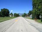
Fielding was founded in 1892 in the Bear River Valley between the Bear River and the Malad River. It was named after Mary Fielding Smith, who was the mother of LDS Church president Joseph F. Smith. Farmland surrounds the town for miles in all directions. Clarkston Mountain is prominently visible to the north, and Wellsville Mountain to the southeast. A few miles to the northeast, the Bear River passes through a gap in the hills from Cache Valley into the Bear River Valley.
Fielding has been bypassed by major highways. U.S. Highway 191 originally passed by a few miles to the west, and is now designated Utah Highway 13. The southern route of U.S. Highway 30 originally crossed the Bear River just a mile south of Fielding. That route is is no longer extant, and modern day Utah Highway 30 passes by further south. Utah Highway 81 was built to connect from Utah Highway 30 to Fielding.
Fielding had a population of 455 in the year 2010 and has not had much growth over the years. The elevation varies from 4,354 feet to 4,375 with a slight rise towards the hills to the east. The bottoms of the Bear River are 130 feet deep, making an obstacle to roads in that direction only breached by Utah Highway 30.
For More Information:
Read about Fielding in Wikipedia.