Entry Points:

About Wellington
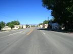
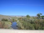
Wellington sits in the lowlands of the Price River in the deserts of central Utah. Grassland and ranchland surround the town, beyond which hills and ridges of yellow earth and rock brighten the landscape. In the distance, the mountains rise in cliffs of reds and yellows.
South of Wellington lies a desert area of rock formations called "Castle Country", and further to the south is the San Rafael Swell, an rugged area of scenic cliffs and canyons. To the north and east the desert gives way to mountains and forests.
Wellington has a near neighbor a few miles away called Price, the largest city of the area. U.S. Highways 6 and 191 (a combined route) pass through Wellington on Main Street and then turn northwest to connect to Price. East of town they turn to the southeast to pass along the Book Cliffs and eventually reach Green River. Coal mining drives the local economy and the facilities and equipment are frequently seen around town.
The elevation at Wellington is 5,413 feet and the population was 1,666 in the year 2000. It was settled in 1878 by Mormon pioneers led by Jefferson Tidwell.
For More Information:
See the Wikipedia article on Wellington.