Entry Points:

About Manila
Manila received it's name in 1898 from Adolph Jesse, who surveyed it, in commemoration of the victory over the Spanish fleet at Manila, Philippines. In 1917, when Daggett County was created, Manila was named the county seat, being the only real town in the county.
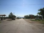
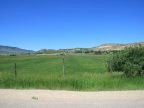
It is located against the hills on the northern side of Lucerne Valley, a remote valley tucked between the north slopes of the Uinta Mountains and the Wyoming border. Flaming Gorge Reservoir covers the eastern end of the valley. Farmland fills the valley to the south of the town, and the Uinta Mountains rise dramatically on the other side of the valley. The scenery, with the blue water of the reservoir, and the jagged mountains, and forests and grassland, is truly striking.
As of the year 2000, the population was 308. The elevation is 6,360 feet. Utah Highway 43 passes east-west through the town, being a short stretch of highway that comes in from Wyoming a few miles to the west and passes back into Wyoming a short distance to the east. Utah Highway 44 begins at Manila and heads south, climbing up the steep slopes of the Uinta Mountains to it's junction with U.S. Highway 191.
For More Information:
Manila’s official website is found at www.manilautah.com. See also the Wikipedia article on Manila, Utah.