Entry Points:

About Meadow
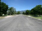
Meadow was settled in 1857 by Mormon pioneers who came from Fillmore, a town eight miles to the north. It is named after meadows located there which made productive farmland. The town is situated on the eastern edge of the Sevier Basin, and at the feet of the Pahvant Mountains, which provide a beautiful backdrop to the city on the east. The Sevier Basin extends for many miles to the west and becomes very dry and inhospitable, with lava covering some areas.
Meadow is sparsely settled still today, with only 254 residents at the 2000 census. The town is laid out in typical Mormon fashion, with a grid of large blocks aligned to the compass, with just a few streets in each direction. Interstate 15 passes by the town. The Main Street used to be U.S. Highway 91. The section south of Meadow has been designated Utah Highway 133 and it leads to Kanosh. Interstate 15 connects to Fillmore. The elevation at Meadow ranges from about 4,820 to 4,920 feet.
The Ute Indian chief Walkura died at Meadow in 1855. The place was known as Meadow Creek at that time.
For More Information:
See Wikipedia, Meadow, Utah.