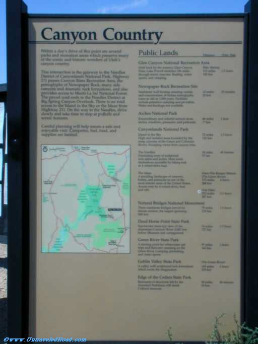
Canyon Country
Within a day's drive of this point are serveral
parks and recreation areas which preserve many
of the scenic and historic wonders of Utah's
canyon country.
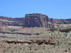
This intersection is the gateway to the Needles
District of Canyonlands National Park. Highway
211 passes Canyon Rims Recreation Area, the
petroglyphs of Newspaper Rock, many side
canyons and dramatic rock formations, and also
provides access to Manti-La Sal National Forest.
The paved road ends in the Needles District at
Big Spring Canyon Overlook. There is no road
access to the Island in the Sky or the Maze from
Highway 211. On the way to the Needles, drive
slowly and take time to stop at pulloffs and
scenic features.
Careful planning will help insure a safe and
enjoyable visit. Campsites, fuel, food, and
supplies are limited.
| Public Lands | Distance | Drive Time |
| Glen Canyon National Recreation Area Held back by the massive Glen Canyon Dam, Lake Powell stretches 186 miles through scenic canyons. Boating, water sports and camping. | Hite Marine 113 miles 182 km | 2.5 hours |
| Newspaper Rock Recreation Site Sandstone wall bearing amazing variety and concentration of Indian petroglyphs, some as old as 1,000 years. Facilities include primitive camping and pit toilets. Water and hookups not available. | 12 miles 20 km | 20 minutes |
| Arches National Park Extraordinary and colorful natural stone arches, windows, pinnacles, and pedastals. | 46 miles 77 km | 1 hour |
| Canyonlands National Park | ||
| Island in the Sky High and isolated mesa bounded by the steep canyons of the Green and Colorado Rivers. Sweeping views from canyon rims. | 72 miles 120 km | 1.5 hours |
| The Needles Fascniating array of sculptured rock spires and arches. Most scenic destination accessible by hiking trail or 4-wheel-drive road. | 34 miles 57 km | 45 minutes |
| The Maze | Hans Flat Ranger Station | |
|
A puzzling landscape of canyons, buttes, and pinnacles in one of the most remote areas of the United States. Access only by 4-wheel-drive, foot, and raft. | (Via Green River) 173 miles 288 km | 4 hours |
| (Via Hite) 232 miles 387 km | 5.5 hours | |
| Natural Bridges National Monument Three sandstone bridges carved by stream erosion, the largest spanning 268 feet. | 75 miles 125 km | 1.5 hours |
| Dead Horse Point State Park Spectacular mesa-top view of the serpentine Colorado River 2,000 feet below. Museum and campground. | 76 miles 127 km | 1.5 hours |
| Green River State Park A staring point for whitewater raft trips and flatwater canoeing on the Green River. Camping, picnicking, and water sports. | 97 miles 162 km | 2 hours |
| Goblin Valley State Park A valley with sculptured rock formations which excite the imagination. | 145 miles 235 km | 2 hours |
| Edge of the Cedars State Park Remnants of structures left by the Ancestral Puebloans still stand. Cultural museum. | 38 miles 63 km | 40 minutes |