Entry Points:

About Coalville
Coalville was settled in April of 1858 in the valley of the Weber River, on the banks of Chalk Creek. Several miles to the northwest ran the route of the Mormon Trail as it emerged from Echo Canyon and reached the Weber River. William Henderson Smith was attracted to the location when, traveling through the area, he came upon wheat that had voluntarily sprouted up from spillage from previous travelers' wagons. Andrew Williams and Leanard Phillips joined him in founding the settlement, which was named Chalk Creek.
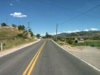
The valley of the Weber River stretches southward from Coalville for several miles, being less than a mile wide, and rimmed by sagebrush-covered hills, punctuated by rocky outcroppings of rock. A prominent ridge of light-colored rock juts out of the hills just north of Coalville. Today lush farmland fills the valley and cottonwood trees grow in clumps along the river. North of Coalville lies the Echo Reservoir, built to take advantage of the abundant water of the Weber River. Eastward from Coalville, Chalk Creek flows through a valley that climbs gradually through a narrow valley.
Coal was soon discovered in the nearby hills and the town's name was changed to Coalville. LDS Church President Brigham Young, who spearheaded the settlement of Utah, assigned Daniel H. Wells, Briant Stringham, and Stephen Taylor to develop the mine into an important resource for the early Utah population. It was named the "Old Church Mine."
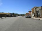
At 5,580 feet in elevation, Coalville enjoys mild summers with correspondingly cold winters. The population was 1,382 in the year 2000, not far from the figure of 1,200 it had in 1908. It is the county seat of Summit County. Interstate 80 passes by the town on the west. The old highway which winds along the valley's eastern edge, and passes through Coalville on Main Street, was U.S. Highway 189 prior to the construction of the freeway, and the Lincoln Highway before that. Chalk Creek Road, a paved highway, follows Chalk Creek far eastward to the Wyoming border.