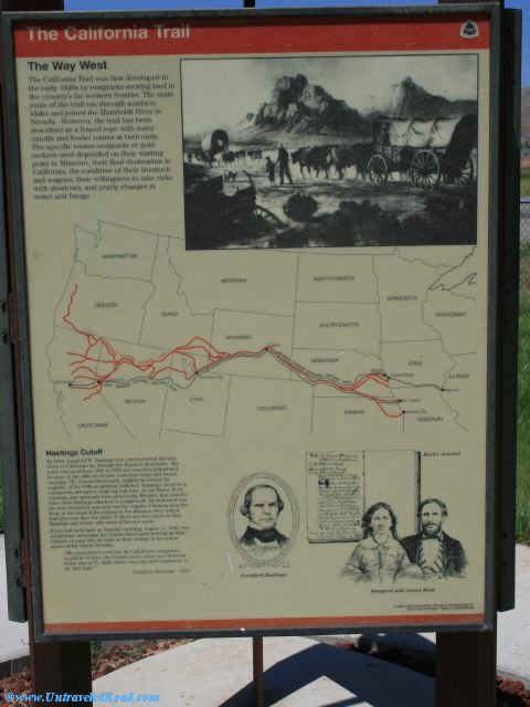
The California Trail
The Way West
The California Trail was first developed in
the early 1840s by emigrants seeking land in
the country's far western frontier. The main
route of the trail ran through southern
Idaho and joined the Humboldt River in
Nevada. However, the trail has been
described as a frayed rope wth many
cutoffs and feeder routes at both ends.
The specific routes eimgrants or gold-
seekers used depended on their starting
point in Missouri, their final destination in
California, the conditions of their livestock
and wagons, their willingness to take risks
with shortcuts, and yearly changes in
water and forage.
Hastings Cutoff
By 1845, Lansford W. Hastings was convinced that the best
route to California lay through the Wasatch Mountains. His
route ws used from 1846 to 1852 and was then abandoned
because of the difficult 83-mile waterless Great Salt Desert
crossing. The Donner-Reed party, lagging far behind the
majority of the 1846 emigration, followed Hastings' shortcut in
a desperate attempt to make up lost time. At the Weber River
crossing, just upstream from present-day Henefer, they found a
letter from Hastings attached to a sagebrush. He indicated that
the trail downriver was very bad for wagons. Camping near the
river, at the head of the canyon in the distance, they waited
four precious days for James F. Reed and two others to find
Hastings and retur with news of his new route.
If you had been here on Tuesday morning, August 11, 1846, you
would have witnessed the Donner-Reed party moving up Main
Canyon, to your left, en route to their destiny in the winter
snows of the Sierra Nevadas.
"The most direct route for the California emigrants,
would be to leave the Oregon route, about two hundred
miles east of Ft. Hall; thence bearing west southwest, to
the Salt Lake."
--Lansford Hastings - 1845