Entry Points:

About Mendon
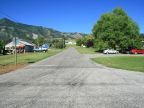
Mendon sits at the edge of Cache Valley at the base of the Wellsville Mountains, with Mendon Peak towering above it. The valley stretches to the horizon to the north, and the sheer face of the Bear River Mountains lines the far side of the Valley. To the west, the Wellsville Mountains reduce in size towards the north until they are just a line of hills. East of Mendon the Cache Valley becomes swampy, and the best farmland is on the higher ground closer to the mountains.
Mendon was settled by Mormon pioneers who arrived in 1859 and 1860, coming from Great Britain and Denmark. The town was originally built with log cabins arranged as a fort to protect the settlers from Indian attacks. The cabins were later moved onto the surrounding lots and then many were replaced with homes built of stone, some of which still stand today.
Mendon is off the major travel routes in the area, allowing its rural flavor to be preserved. State Highway 23 passes through the town on First West Street, leading south to Wellsville and north to a junction with Utah Highway 30. The elevation ranges from 4,440 feet to 4,600 feet. Mendon Peak is just a few miles east and a bit south of town, and is 8,746 feet tall.
For More Information:
See Mendon’s official site at www.mendoncity.org
and the Wikipedia article Mendon, Utah.