Entry Points:

About Paragonah
Paragonah was settled in 1852 by Mormon pioneers, but was abandoned because of skirmishes with Indians. In 1855, a fort was built, with houses built along the inside of the walls, and the town was resettled. It was originally named Red Creek, named after the colored rocks in the mountains where the creek flows out into the valley The name is a Piute Indian word which reportedly means "many watering holes."
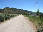
Paragonah lies near the mountains on the east side of Parowan Valley. The mountains are apparently unnamed, but the red cliffs facing them are called the Hurricane Cliffs, characterized by red rock, contrasted by dark green juniper and cedar trees. The valley is about five miles wide and another mountain range fronts it on the northwest. On both sides of the valley, the elevations reach to above 7,000 feet, contrasting the 5,900 feet at Paragonah.