Entry Points:

About Lynndyl
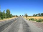
Lynndyl is a tiny farming and railroad town on the edge of the Sevier Desert. The Gilson Mountains and the Canyon Mountains lie several miles to the east and the Sevier River flows between them and past Lynndyl. Lynndyl is built on a bluff overlooking the river bottoms. To the west and southwest the flat Sevier Basin extends for many miles and mountains on the other side can barely be seen on a clear day. With irrigation water from the river, patches of the surrounding country are farmed.
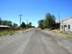
Lynndyl was settled in 1907 as a stop on the railroad, and farming began in the area in 1912. Lynndyl is also a stop on U.S. Highway 6, and the remnants of an old gas station can be seen on a corner of Main Street, where the highway used to run. Since then the highway was re-routed along Second East, and a modern gas station operates on the highway at the south end of town.
The Little Sahara Sand Dunes cover many square miles a short distance to the north of Lynndyl. They are designated a National Recreation Area, and are a popular resort for residents along the Wasatch Front, who come for dune buggy and RV riding.
The population is 134, as of the 2000 census, and the elevation is 4,780 feet. Lynndyl is in Millard County, but the Juab County line is just a few miles to the north. U.S. Highway 6 heads southwest from Lynndyl to Delta, the nearest larger town. It heads northward to Eureka and then turns east into Utah Valley. State Highway 132 begins at Lynndyl and heads east to Nephi.
For More Information:
See Wikipedia's Lynndyl article.