Entry Points:

About Uintah County
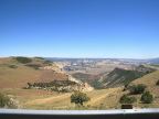
Uintah County occupies a major portion of the Uintah Basin, a region bordered by the Uintah Mountains on the north, the Wasatch Mountains on the east, the Tavaputs Plateau and Book Cliffs on the south, and outliers of the Colorado Rockies on the east. Duchesne County, on the west, and Colorado's Moffat and Rio Blanco counties to the east, occupy the rest of the basin. The northern border of Uintah county follows the peaks of the Uintah Mountains, and the southern boundary cuts through the Tavaputs plateau.
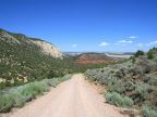
While a rugged country of high mountains and steep canyons, plateaus and mesas, and a wide scattering of angular hills covers most of the county, a fertile agricultural exists at the feet of the Uintah Mountains, named Ashley Valley. The city of Vernal is found here, along with Napes, Maeser and Jensen, and most of the population of the county. Water flows out of the Uintah Mountains in Ashley Creek and others, providing the for needs of agriculture.
The Uintah Mountains and the Green River are the two major physiographical features of the county. The Uintah Mountains contain the highest point in the county at 12,276 feet. Their great elevation makes them important in capturing rain and winter snows. Beautiful forests, alpine lakes, and snow-capped peaks provide not only scenery and recreation for people, but also an important habitat for wildlife.
The Green River traverses the Uintah Mountains through a series of dramatic canyons. It enters Uintah County in Whirlpool Canyon, then after a brief respite, passes through Split Mountain Canyon. It then enters the Uintah Basin and Ashley Valley and heads southward. It leaves the county in the southwest corner, cutting through the Tavaputs plateau in Desolation Canyon. Eventually it joins the Colorado River.
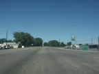
Uintah County has a population of 25,244 people, and covers the large area of 4,499 square miles. U.S. Highway 40 passes through Ashley Valley, traveling east-west, and U.S. Highway 191 makes the crossing over the Uintah Mountains from the north, arriving at Vernal. From here it joins highway 40 and goes west. The southern half of the county is part of the Uintah and Ouray Indian Reservation.
Dinosaur National Monument lies partially in Uintah County, and includes Split Mountain Canyon and Whirlpool Canyon. The monument preserves a rich fossil bed where dinosaur skeletons have been found.
Street Index
|
12500 South Street 5500 East Street 6800 East Street a dirt road |
Ashley Creek Blue Mountain Road Bonanza Road Highway 2776 |
Musket Shot Springs Green River U.S. Highway 40 |