Entry Points:


About Blanding
Blanding is located in the rugged country in the southeast corner of Utah. Sitting at 6,100 feet on White Mesa, the horizon is dominated by the Abajo Mountains (also called the Blue Mountains), which lie just to the north. From Blanding the ground slopes steadily upward to forested slopes of the mountains. White Mesa extends several miles south of Blanding, surrounded on both sides by steep drops. The surrounding country is uninhabited, scored by deep canyons and chasms and cliffs. Juniper and cedar trees are common all around the area, as well as sagebrush.
Blanding was settled in the first years of the 1900s. A canal was laid out in 1902 to provide irrigation water from the Blue Mountains and families of Mormon pioneers began arriving a couple years later. Many of them were part of the famous "Hole in the Rock" expedition, so named after the difficult place where they crossed the Colorado River. At first the settlement was known as Grayson, after Nellie Grayson Lyman, one of the first settlers. In 1915 it was changed by the Postal Service to Blanding, to the chagrin of the residents.
The last Indian uprising of the west occurred near Blanding in 1923 led by Ute chief "Old Posey."
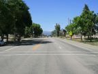
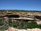
U.S. Highway 191 passes through Blanding, leading to Monticello on the north, and Bluff to the south. The highway makes a ninety degree turn at the intersection of Main Street and Center Street, heading south and east. After going east a few blocks, it turns to the north again. Several rural roads leave the town to the north and west, including Blue Mountain Drive, which climbs right up into the peaks of the mountains. Ruin Road leaves the southwest corner of town and travels a few miles to an ancient Indian cliff dwelling in Westwater Canyon.
The population, as of the year 2010, was 3,375, an increase of about 200 over the past decade. A friendly, Mormon culture dominates the town, but many native Americans live in the area also. The elevation ranges from about 5,900 on the south end of town to about 6,280 on Peanut Knoll, to the north.
For More Information:
Blanding’s official site is at www.blanding-ut.gov. See also the Blanding Chamber of Commerce site, and Wikipedia’s Blanding, Utah article.