Entry Points:

About Monticello
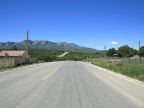
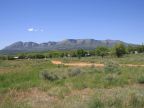
At the feet of the Abajo Mountains, Monticello enjoys a remote location in the rugged terrain of southern Utah. With the majestic, forested mountains reaching above 11,000 to the west, and box canyons to the south and north, the plain it sits on is an island in the middle of a sea of wilderness. With an elevation above 7,000 feet, it is much cooler and wetter than surrounding areas at lower elevations. The land west of Monticello is flat and checkered with farms and ranches, extending several miles to the east and into Colorado. To the north and south of this plateau, steep-walled canyons cut up the land with a rugged terrain, leading to lower, hotter areas. Scrub oak covers the gentle lower slopes of the Abajo Mountains, with evergreens and quaking aspens on the peaks.
Monticello is the closest city to the Needles District of Canyonlands National Park. Formed by the Colorado River’s passage through a deep gorge, Canyonlands is a rugged terrain of cliff-lined tributary canyons dotted with stone monoliths. State Highway 211 accesses the Needles District from a junction several miles north on Highway 191.
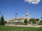
Founded in 1887, Monticello was the first successful attempt by the Mormon pioneers at settling this rugged country. It was named after the estate of Thomas Jefferson, and incorporated in 1910. They laid out a spacious city of broad straight streets and large lots appropriate for family farms. Ranching has been the main source of income, with the addition of tourism in more recent times. Monticello today is a beautiful and healthy community, isolated from urban America, surrounded by nature, and inhabited by people who still know how to help each other. The descendants of the Mormon pioneers still adhere to the same faith, and the LDS Church built a beautiful temple in Monticello, which was dedicated 26-27 July 1998, located on the north end of town.
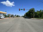
U.S. Highway 191 passes through Monticello, heading north to Moab, and Blanding on the south. U.S. Highway 491 (formerly 666) begins at Monticello, heading eastward to Dove Creek in Colorado. The Colorado border is only a few miles away. The population of Monticello, as of 2010, is 1,972, with no significant change in the previous decade. It is the county seat of San Juan County, as well as its largest city.
In ancient times, the Anasazi Indians inhabited this area and have left ruins in significant numbers. In about 1250 AD, they disappeared on account of severe droughts. Canyons of the Ancients National Monument and Hovenweep National Monument, to the southeast, preserve some of the ruins of these ancient peoples, and others remain in the area.
For More Information:
Monticello’s official site is at www.monticelloutah.org. See also Wikipedia’s Monticello, Utah article.