Entry Points:

About Avon
At the extreme south end of Cache Valley, the town of Avon lies scattered around the spot where East Fork runs into the Little Bear River. The Little Bear River flows out of South Canyon, which extends directly to the south of Avon, and East Fork cuts into the mountains to the east, where they rise the highest. Mountains surround the town in all directions except the northwest, and they are mostly covered in forests. The valley, which is mostly hilly, is covered in farmland.
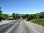
Avon was settled in 1860 but is still unincorporated. 367 people were living here, at the 2010 census. The houses are scattered along rural roads, and the town was never platted. The main road is called South Canyon Road from Avon southward, and it quickly turns to dirt and crosses the mountains into Ogden Valley. To the north it leads to Paradise, where it becomes State Highway 165. The main intersection in Avon is where East Canyon Road meets South Canyon Road. A few other lesser roads take off in various directions. Since the town is not incorporated, it has no defined borders, but everyone at this end of the valley probably considers themselves to be living at Avon.
It is named after Stratford-upon-Avon, a town in England. The 5,000 foot elevation contour passes right through the middle of Avon.
For More Information:
See also the Wikipedia article on Avon.
Street Index
|
11000 South Road 800 East Street East Canyon Road |
South Canyon Road West Canyon Road |