Entry Points:

About Cache Valley
Cache Valley lies on the northern border of Utah, extending partway into Idaho. It is about ten miles wide and extends about thirty miles southward from the state line. It is filled with farmland numerous towns, including Logan, one of the largest cities in Utah. The valley floor is about 4,500 feet in elevation, and the surrounding mountains reach to nearly 10,000 feet. An abundance of moisture provides for beautiful green vegetation both in the valley and on the mountains.
Cache Valley was discovered about by Europeans in 1818 by Michel Bourdon on a fur trapping expedition. It became a meeting place for mountain men, and received its name from their fur caches. Jim Bridger recommended the valley to Brigham Young as a place to settle the Latter Day Saints instead of the Salt Lake Valley which was chosen. But Mormon pioneers soon arrived and settled in 1856.
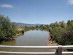
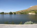
The Bear River, which is the longest inland river in the western hemisphere, flows through Cache Valley. It begins in the Uinta Mountains, to the southeast, and winds around through Wyoming and Idaho, and enters Cache Valley at the northeast corner. It flows through the center of the valley until it reaches a point about halfway down, then it turns west, flows through a gap in the mountains, and exits Cache Valley. Two other significant rivers join it, the Little Bear River, coming from the south end of the valley, and the Logan River, flowing out of Logan Canyon, on the east side. Numerous other creeks flow out of the mountains. The Cutler Dam was built on the Bear River where it exits the valley, forming the Cutler Reservoir. Much of the center of the valley surrounding it and the Bear River is swampy.
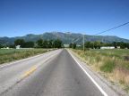
The Bear River Mountain Range lines the eastern edge of the valley, a dramatic, rocky wall which runs the entire length of the valley. These are the highest of the surrounding mountains, and help to bring rainfall to the area. The line of mountains along the western edge of the valley is more broken, and drops to a ridge of hills around the Cutler Dam. South of this point they are called Wellsville Mountain, and north of it Clarkston Mountain.
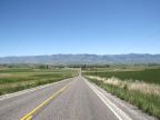
The major highway through Cache Valley is U.S. Highway 91, which enters at the southwest corner, and passes lengthwise through the valley, leaving to the north, being four lanes the entire distance. U.S. Highway 89 also passes through Cache Valley, sharing the same alignment with Highway 91 at the south end, up to Logan, then turning northeast up Logan Canyon. Utah Highway 23 passes along the west side of the valley, and Utah Highway 165 heads south on the east side of the valley, breaking off of U.S. Highway 89 & 91 south of Logan.
This page covers the Utah side of Cache Valley. For a tour on the Idaho end of Cache Valley, see the Franklin County page.
For More Information:
Wikipedia also includes an article on Cache Valley.