Entry Points:

About Logan Canyon
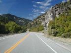
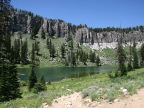
Logan Canyon cuts through the 9,000-foot peaks of the Bear River Mountain Range in northern Utah. Canyon walls over 3,000 feet high sport cliffs of gray stone surrounded in forests of quaking aspen, oaks and evergreens. The Logan River, which originates from the canyon's upper reaches, is one of the major tributaries to the Bear River. Abundant runoff from winter snows keeps vegetation green well into summer. Scarcely can a more beautiful canyon be found anywhere.
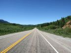
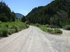
Even though the canyon is winding and deep, it is a fortuitous pass through these mountains, and became a natural selection for the route of U.S. Highway 89, which runs the length of the canyon, providing convenient access to many picnic areas, campgrounds and side roads. The city of Logan, for which it is named, lies right at the mouth of the canyon, where it flows into Cache Valley. Heading east from Logan, the canyon turns to the northeast After climbing about two thousand feet, it widens into an alpine valley called Franklin Basin. From there, the highway follows Beaver Creek to Beaver Basin and then crosses the summit into Bear Lake Valley.