Entry Points:

About Trenton
Trenton lies on the west side of Cache Valley in northern Utah. The Bear River passes by about a mile to the northeast, and Trenton was built on a bluff overlooking Ransom Hollow, a ravine carved out by a creek that flows into the river. A ridge of hills rises just west of Trenton, the largest of which is Little Mountain, which is prominently visible just to the southwest of Trenton, standing a thousand feet higher than the town.
The railroad passes by Trenton on the west side, and Trenton used to be home to agricultural businesses which shipped their goods out by train. Utah Highway 142 passes east-west through Trenton, leading across the valley to Richmond, and up into the hills to Clarkston. Utah Highway 23 passes by Trenton just beyond the train tracks, at the base of the hills, heading north and south.
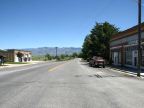
Trenton has a few old shops at the intersection of Main and Center Streets which are probably not too busy now, and only a few side streets form the nucleus of the town. The city limits take in a large area of the surrounding farmland and houses scattered through this area account for much of the population of the town, which wtood at 464 at the 2010 census.
Trenton was settled in 1870.
For More Information:
See also Wikipedia's Trenton article.
Street Index
|
Center Street First East Street First West Street Fourth East Street |
Fourth South Street Main Street Second East Street |