Entry Points:

About River Heights
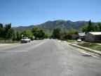
River Heights is a small residential community on the south side of Logan. It is named for its location on a bluff overlooking the bottoms of the Logan River, just north of the town. Being isolated by the river and the steep slopes, it has no commercial interests nor major roads. The Bear River Mountains lie immediately to the east. Logan Peak, just a few miles in to the mountains, reaches a peak at 9,710 feet, and Logan Canyon, a scenic treasure, is just to the northeast.
River Heights was settled in 1883, and was first called “Dry Town.” It was incorporated on October 31, 1934. In 2010 it had a population of 1,734. The city of Providence lies immediately to the south of River Heights. The elevation is 4,560 feet and the top of the bluff River Heights is located on is mostly flat
There are no major roads through River Heights, and it can be a little difficult to find. From Logan, Seventh South Street leads right into River Heights. From Providence, First West Street connects in. River Heights shares the street numbering of Logan, as opposed to Providence which has it's own system. So Providence's First West Street becomes Seventh East Street in River Heights.
For More Information:
See Wikipedia’s article on River Heights article.