Entry Points:

About Wellsville
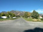
With Wellsville Mountain as a backdrop on the west, and the grasslands of Cache Valley stretching to the east and north as far as forty miles, a group of Mormon Pioneers founded Wellsville on September 15th of 1856. Farmland surrounds the city and slopes upward for a mile to the forested base of the Mountains. The Little Bear River passes by the northeast corner of town.
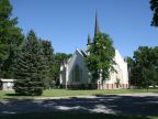
The city was laid out by the settlers with broad streets in ten-acre blocks divided into 1.25 acre lots. On a square in the center of town the Wellsville Tabernacle was built of local materials by volunteer labor in 1902-1908. While no longer in service as a meetinghouse, it is preserved by the city as a landmark and reminder of the city's heritage.
2,728 people live in Wellsville as of the year 2000. The elevation ranges from 4,480 to about 4,600 feet in elevation. U. S. Highway 89 and 91, a combined route, passes by on the southeast of town, crossing the valley to Logan, and the mountains to Brigham City and I-15. Utah Highway 23 heads north from Wellsville, following the western foothills to Mendon, and Utah Highway 101 crosses the valley eastward toward Hyrum and Blacksmith Fork Canyon.
For More Information:
Read about Wellsville in a Wikipedia article and the city's official site at wellsvillecity.com